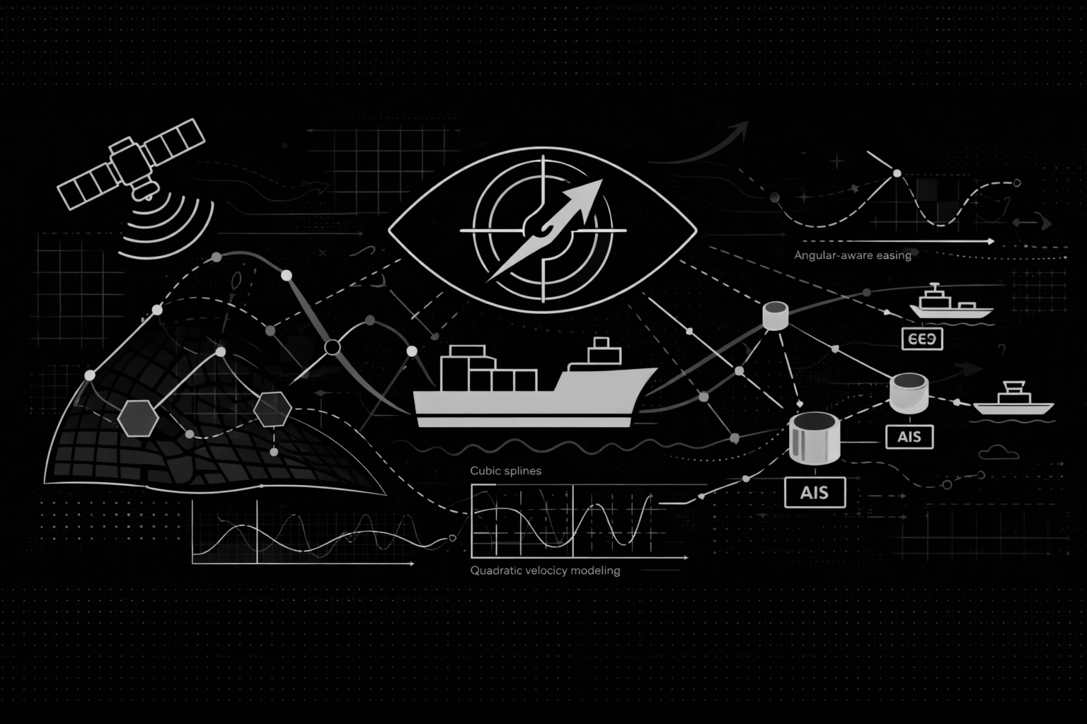
Trajectory Reconstruction: Interpolation
Our Interpolation engine reconstructs vessel trajectories during AIS data gaps using physics-based cubic spline interpolation, quadratic speed modeling, and smooth angular transitions to create continuous, realistic paths.
Series: Maritime Domain Awareness
- Part 1Maritime Domain Awareness System: Technical Overview
- Part 2Vessel Detection
- Part 3Correlation Engine: Matching Detections to Vessel Identities
- Part 4Trajectory Reconstruction: Interpolation
The Automatic Identification System (AIS) provides position data at irregular intervals. A vessel may transmit at 14:32:07 UTC, then go silent until 14:47:33 UTC due to signal loss, satellite coverage gaps, or deliberate transmission disablement.
During these gaps, the vessel continues moving. OS² must reconstruct the path taken during periods without data. This document explains how the system fills gaps in AIS data using physics-based methods.
The Problem with Linear Interpolation
Standard trajectory reconstruction uses linear interpolation—drawing a straight line between two data points. This approach ignores physical reality. Ships have mass and inertia. They cannot instantaneously change heading or speed without gradual acceleration and turning arcs determined by hydrodynamics.
Linear interpolation produces unrealistic results: vessels appear to move in sharp zig-zags with instantaneous velocity changes. To achieve accurate maritime awareness, the system must model how actual vessels move through water.
Cubic Spline Interpolation for Position
OS² uses cubic spline interpolation for position data. This method constructs piecewise third-degree polynomials between consecutive data points. The spline algorithm enforces three physical continuities:
- Position Continuity: The path remains unbroken without teleportation.
- Velocity Continuity: Speed changes are smooth without sudden jumps.
- Acceleration Continuity: Acceleration is continuous without instantaneous force changes.
The algorithm solves a tridiagonal matrix system to define a curve that minimizes bending energy. This produces the path that a physical object would naturally follow through a fluid medium. The result is a smooth trajectory that respects the laws of physics governing vessel movement.
Quadratic Interpolation for Speed
Velocity changes more gradually than position. A vessel applying thrust experiences a delay before reaching cruising speed. Similarly, a vessel cutting engines glides gradually before stopping.
OS² models speed using quadratic interpolation. By fitting a parabola to neighboring speed reports, the system captures the acceleration characteristics of the vessel. This approach correctly predicts when a vessel likely exceeded its final stable speed during acceleration before settling to the reported speed. This level of detail distinguishes a physically realistic simulation from a simple data interpolation.
Angular Interpolation for Course
Course Over Ground (COG) presents a unique challenge due to the circular nature of compass headings. A turn from 350 degrees to 10 degrees represents a 20-degree starboard adjustment, not a 340-degree rotation to port. Standard algorithms often fail this wraparound problem.
Additionally, a vessel's rudder does not instantly change the ship's heading. The rate of turn starts slowly, accelerates during the maneuver, and dampens as the new course is established.
OS² replaces linear angular interpolation with a smooth-step easing function:
This equation creates a sigmoid curve that models the hydrodynamic response of a rudder-steered vessel. It eliminates sharp angular changes and replaces them with the smooth curves of actual navigation.
Spherical Geometry for Global Navigation
At high latitudes, Earth's curvature makes Euclidean geometry inaccurate. Using flat-plane calculations introduces unacceptable errors.
OS² enforces spherical trigonometry for all calculations. Distance, velocity vectors, and spatial separation are computed using the Haversine formula:
Where R is Earth's radius, φ represents latitude, and λ represents longitude.
This ensures accurate trajectory reconstruction whether the vessel operates at the equator or the Arctic.
Performance Results
The physics-based interpolation approach has been validated through rigorous testing. In trials using AIS data with ninety-five percent random packet loss (simulating hostile or degraded signal environments), the OS² interpolation engine achieved a Root Mean Square Error (RMSE) of . This significantly outperformed standard linear interpolation, Hermite interpolation, and Kalman Filter approaches.

The raw AIS data shows sparse position reports separated by gaps. The interpolated trajectory fills these gaps with smooth, physically plausible paths. Vessel movements that appear as jagged zig-zags in raw data become continuous curves that respect the vessel's inertia and turning capabilities.
Complete Architecture Overview
OS² integrates three core functions:
- Detection: Identifies vessels in satellite imagery using deep learning models.
- Correlation: Matches detections to vessel identities using AIS broadcast data.
- Interpolation: Reconstructs vessel trajectories during data gaps using physics-based methods.
Detection transforms raw electromagnetic observations into vessel locations. Correlation assigns identities to these locations. Interpolation creates continuous trajectories connecting all available position reports.
Together, these systems convert fragmented satellite and AIS data into a coherent, actionable intelligence picture of maritime activity. This approach provides understanding of vessel movements past, present, and predicted across the entire maritime domain.
Conclusion
Traditional maritime surveillance relies on acquiring more sensors or increasing update frequencies. OS² takes a different approach by extracting maximum information from existing data through advanced signal processing and physics-based modeling.
By integrating computer vision, optimization algorithms, and kinematic physics, OS² transforms incomplete maritime data into comprehensive surveillance coverage. The system provides visibility into vessel movements even when individual data sources contain gaps or are deliberately obscured.
This framework shifts maritime awareness from reactive observation to proactive intelligence. Vessel movements that were historically unknown or discovered only after the fact now become predictable and observable through computational analysis of available data sources.